Tuesday, November 17, 2015

The Cold War & the Home Front: Owingsville's Air Force Station

There was a period in recent time when America lived in a state of constant readiness.  We lived under the assumption that one day, communist forces from the USSR and Cuba would attack The United States and spark the dreaded Third World War; a nuclear war that could obliterate our cities and lives.  At the end of World War II in 1945, the United States and USSR (Russia) dominated world affairs.  Berlin, Germany's capital city, was divided, with the United States and Allied Forces occupying the west, and the Russians occupying the east.   The US, British and French occupied the entire western and southern sections of Germany.  Russia's leader, Joseph Stalin, counted on the allies to vacate Germany within a couple of years, and there would be a total communist control over the country.  Tensions arose in 1948 when the Russians blocked the crucial transportation routes into Berlin and the region was once again at the brink of war.  Luckily, the blockade was resolved in May, 1949 and the region stabilized again.  Berlin was again at the center point of world affairs when in 1961, the Berlin Wall was constructed by the Russians, dividing the city for twenty-eight years.

As the 1950's dawned, the newly formed North Atlantic Treaty Organization, or NATO, was tested with the Korean War.  Communist forces under the direction Kim Il-sung invaded South Korea, allegedly under the advisement of the Joseph Stalin.  The war was a brutal fight, ending in 1953 with over thirty three thousand United States deaths.  Tensions between the USSR and US continued, and by the 1960's, Cuba was a player in the field.  The Cuban Missile Crisis in 1962 nearly brought the world into an all out nuclear war.  A failed coup attempt to oust communist Cuban leader Fidel Castro at the Bay of Pigs resulted in the positioning of nuclear-armed missiles by Russia on the Cuban mainland; well within striking distance of the Untied States.  A tense stand off brought a nuclear war closer than it ever had, or has, been and was resolved diplomatically.

All the tensions, provocations and fear of war mobilized the United States into readiness mode.  The armed forces, particularly the Air Force, prepared for the anticipated event of war by bolstering air defenses on land and in space.  Intercontinental ballistic missiles could strike targets thousands of miles away by the push of a button, so early warning systems were designed to better protect us.  Powerful radar systems and a series of transmitters were strategically built nationwide, providing a web of protection against nuclear strikes.  In the meantime, everyday citizens of all ages were taught to 'duck and cover' and participated in drills in their homes, workplaces and schools.  No one appeared safe from the nuclear threat; large cities, military facilities and small town America was in harm's way.  Part of this readiness mode brought the Cold War right into Bath County.

The Air Defense Command was activated in 1946 by the United States Air Force to provide a blanket of defense from attacks by planes or missiles.  The Russians were building larger and better ranged bombers that could strike key targets and large municipalities, so early warning was integral.
A deployed mobile AN/TPS-1D radar system
Forty-four mobile radar stations were built nationwide to supplement the stationary radar sites, a kind of mobile-relay system.  Originally slated for full operation by 1952, budget limits, site changes and other factors delayed the implementation of the mobile sites and in 1954, the 809th Aircraft Control and Warning Squadron was activated at the newly constructed Owingsville Air Station; officially designated as M-131.  Owingsville Station was part of the 4708th Air Defense Wing based out of Selfridge Air Force Base in Mt. Clements, Michigan.  The barracks, mess hall, motor pool, support and personnel buildings were located off Kentucky Highway 36 West, just prior to Tunnel Hill Road.  A mobile AN/TPS-1D type radar was placed on the garrison site until the station was fully operational in 1956.  A tactical operations site was constructed a few miles north of the garrison site, on a hillside adjacent to Powers Branch Road.  The tactical site featured a few buildings and a stationary mounted radar that functioned as a Ground Control Intercept station.  The role of the station was to guide aircraft to intercept incoming, unidentified threats using the other radar systems within the links of the air defense chain.  The station was called a 'manned gap-filler' type site due to the relay capabilities.   Major Frank Smyth was the commander for the 809th AC&W Squadron, Second Lieutenant Robert Poline served as the Adjutant at the small garrison, and together with a small force of Airmen, they maintained a constant, watchful eye on the skies above and beyond.  Amenities at the station were modest; barracks lined one side of the facility, the motor pool where all the vehicles were parked was on the back side against Prickly Ash Creek, and a few other buildings rounded out the perimeter. 
Owingsville Air Force Station, 1957
The 809th Aircraft Control & Warning Squadron's tactical site
In March, 1956, the 809th Squadron was placed under the command of the 58th Air Division, based at Wright-Patterson Air Force Base in Dayton, Ohio.  The 58th Air Division yearbook from 1957 provides some great photographs and insight of the operations  that went on at the Owingsville Air Force Station. 
From the 58th ADD 1957 Yearbook
No major incidents were ever publicly revealed, mainly due to the intense secrecy that guarded our National safety.  Budget cuts across the armed forces caused the reduction or closure of many radar stations across the country, including the Owingsville Air Force Station in November, 1957.  The station was then operated as an unmanned radar annex controlled by the Snow Mountain Air Force Station located in Fort Knox, Kentucky.  The site on Powers Branch Road was slated to be upgraded to an AN/FPS-18 radar system, but the garrison on Kentucky 36 was abandoned and dismantled.  Site control was then transferred the Guthrie Air Force Station in West Virginia until sometime in the early 1960's before it was closed completely.  The larger AN/FPS-18 radar was never constructed.

The Cold War effectively ended with the fall of the Berlin Wall in 1989 and the USSR consolidating, but threats till loom on a smaller scale.  Today, the 809th Aircraft Control and Warning Squadron command and tactical stations are unrecognizable as places that once helped insure National security by watching our skies.  The garrison site is now home to the Kentucky Department of Transportation garage and the Powers Branch site is now privately owned land.
On this hill was the 809th
Aircraft Control and Warning Squadron's radar site.  Located on Powers Branch Road, off KY 36 West.

Owingsville Air Force Station command site, September 2014 (courtesy of Google Map)


It is highly unlikely that Bath County will ever host another gap-filler radar station for the United States Air Force.  Changes in technology and global security has made these small stations obsolete, but for a short time, Owingsville was an integral part of our nation's defense.


Resources:

 http://www.radomes.org/museum/showsite.php?site=Owingsville+AFS,+KY

Google Maps 

The 58th Air Division archives
 

Friday, June 5, 2015

Pioneer Exploration and Early Settlement in Bath County

When early pioneers trekked from Virginia into what was then the 'Far West', they were astounded by the natural beauty Kentucky offered. Most explorers entered Kentucky via the Cumberland Gap near present day Middlesboro and traveled the Wilderness Trail, which was forged by pioneers such as Daniel Boone. In fact, several well worn trails existed; forged by the Native Americans over generations. One trail, the Warrior's Path, led directly through what is now Bath and Montgomery Counties. It was used by the Native Americans as a hunting path and trade route between villages across the Ohio River and the central part of Kentucky, including nearby Blue Licks. The trail split into two paths just north of Sherburne at Upper Blue Licks; one continuing North to Blue Licks and Limestone, which is now Maysville, and the other path northeast to Chillicothe, Ohio where a large Shawnee village was located.
An early map of settler and native paths
Early Kentucky settlers heard stories of another great Shawnee village called Eskippakithiki that was located in what is now Clark County near the Powell and Montgomery County borders and was abandoned sometime around 1769. Early writings tell of the great village as early as 1670. This site was established as a fur trading post by early explorer John Finley until the outpost was attacked by a group of Ottawa raiders in 1753. During this era, what is now Bath County was largely untamed wilderness with open lowland areas that bordered the Licking River, Slate Creek and Flat Creek. Members of the Shawnee, Wyandot, and Iroquois  Tribes, along with small groups of Cherokee, hunted the region and gathered salt at the various mineral springs that gave the county its name. For the most part, Bath County was left untouched until around 1775.


 As the American Revolution drudged on between 1765 and 1789, the explorations into Kentucky had already been in full swing for a number of years. Known as Kentucky County, Virginia in 1776, early settlers were establishing homes, stockades and stations by the mid 1700's. It is said that the first white man to view Kentucky was James Salling, who was taken captive by natives around 1725 while on an hunting expedition. James Harrod established a stockade later known as Harrodsburg in 1774, making it the first known permanent settlement in Kentucky. Boonesborough followed the next year, and it was near this time that the first known treks into Bath County began. Daniel Boone and his company of settlers would follow the water ways of Hinkston Creek over to Slate Creek, into Bath County to the Licking River at Wyoming and up to Blue Licks to gather salt. Another route was via Flat Creek to its confluence with the Licking River at Sherburne. Either path would have been treacherous, as these were paths natives used on their expeditions. It was on one of Boone's trips to the salt licks that he and his party were captured by Shawnees, culminating in the 1778 Siege of Boonesborough. In 1776, Boone's daughter and two of Colonel Richard Calloway's daughters were abducted by a group of Cherokee and Shawnee raiders and force marched north toward the Ohio River. The alarm was quickly raised at Fort Boonesborough and a rescue party led by Daniel Boone gave chase. The captors and girls took a route that brought them across the Warrior's Path into northern Bath County where they camped for an evening.
A painting depicting the rescue of the Boone and Calloway girls
Boone and his party caught up to the raiders sometime before daybreak and waited. As the raiders prepared breakfast just prior to  sunrise, a shot rang out from the rescue party, wounding two of the natives. The others hastily ran away, leaving the girls at the camp site, which, by some accounts, was located  along Bald Eagle Creek just east of Sharpsburg.

According to John Richards' book A History of Bath County, Simon Kenton, John Strader and George Yader explored down the Licking River to the mouth of Salt Lick Creek in 1771, possibly the first explorers in the area. The earliest known settlement structure in what would become Bath County was a small cabin erected by Elias Tolin along Slate Creek near the Bourbon Iron Furnace site. Tolin was an Irish immigrant born in 1755 and served in the Revolutionary War with the 1st and 11th Virginia Regiments. After the war, Tolin was among those who migrated west into Kentucky and was granted land rights as a veteran through the Commonwealth of Virginia. In order to qualify for a land grant, settlers would have to build an 'improvement' on the property, stockade the property to defend against natives, and plant crops. John Allkire settled along the mouth of Slate Creek near the Wyoming community in 1777, being the second known settler in what was to be Bath County. Thomas French established a settlement along Prickly Ash Creek around 1778, about a half mile from where it empties into Slate Creek. That land and settlement would be absorbed into John Hensley's land grant of two thousand acres in 1780. This was a problem with many settlers of the time; overlapping land grants and confusing property lines would be debated in court for generations after the post Revolution migration period. Hugh Sidwell, Thomas Clark and his brother, along with a Ballard individual, built a settlement at the mouth of Naylor Creek around 1783; this being the first permanent settlement in Bath County. Today, a small white house stands at the junction of Naylor Road and Kentucky 111 on the approximate location of this settlement. Between 1784 and 1794, more settlers began moving into what is now Bath County and the Springfield Church was established in 1794.

 By 1780, Kentucky was divided into three counties; Lincoln, Jessamine and Fayette. The far western area of the state was known as Chickasaw Lands. The land that would become Bath County was part of Fayette County until 1786, when Bourbon County was formed and encompassed the land. Jacob Myers, a German immigrant, surveyed and entered into patent around ten-thousand acres of land along Slate Creek and Mill Creek in 1785. Talks of rich deposits of iron ore and other minerals led Myers to the area, and in 1791, he began to construct an iron smelting operation with a large stone blast furnace. This would be the first iron furnace to be constructed west of the Allegheny Mountains and would be called the Bourbon Iron Works. The furnace went into operation in 1792 and remained a primary source for iron materials for many years to follow. While the furnace was in operation and the area was being settled, Native Americans began to harass, and in one instance kill arriving settlers. Soon after Jacob Myers surveyed the land where the furnace was to be erected, a blockhouse was built to defend workers and residents. The blockhouse was a fortification located just above the site of the furnace
A typical pioneer blockhouse
and provided protection against attackers. It was garrisoned by seventeen men of the Kentucky State Militia from 1790-1796 to quell any further native attacks on the iron works. While the exact location of the blockhouse has been lost to history, there is an old spring next to a residence across from the Bourbon Iron Furnace Park entrance that allegedly was very near the site.

 During those early days of Bath County and the surrounding region, many settlers established what were called stations as a form of protection. Ralph Morgan built a station along Slate Creek in what is now Montgomery County near present day Howard's Mill in 1789. It originally consisted of three cabins facing each other. Because of a few isolated incidents between the settlers and natives, Morgan and the other settlers erected a large stone house and stockade around the cabins to protect themselves. Two miles northeast from Morgan's Station was Peter Fort's Station, which, geographically, would have been in or very near Bath County near the Peeled Oak community. About a mile from Fort's Station, John Troutman built a station, also somewhere near Peeled Oak. Between the two stations, Thomas Hansford built a station in 1792. These stations provided a network of protection along the Slate Creek region between Bath and Montgomery Counties. Another station, Gilmore's Station, was located twelve miles east of Mount Sterling and built in 1792; undoubtedly in Bath County, but at this time, I am unaware of the exact location. Older stations in neighboring Montgomery County, such as Fort Baker (1790), Anderson's Station (1779) and Bradshaw's Stockade (1791) were integral for the settlements east of Fort Boonesborough and Fort Harrod. Along Flat Creek near Bethel,settlers in the area built the Old Stone Fort around 1791 to better protect themselves against natives who traveled from Blue Licks into inner Kentucky. The 'fort' was a large stone two story house built similar to Morgan's Station in Montgomery County, with thick walls and small ports from which settlers could fire at incoming native attackers if needed. Today, the house is nothing more than a shell of stone standing in the forest; a reminder of one of Bath County's earliest settlements.
The Old Stone Fort from a 1961 publication
The Old Stone Fort site, May 2015
In 1792, the hostilities between the natives and settlers had calmed for the most part, but that all changed in April 1793. Morgan's Station was attacked by a group of Shawnees led by a Cherokee chieftain April 1, 1793. The attackers took nineteen captives of women and children and marched them toward Ohio; taking a route toward present day Hope, and briefly into Bath County. A party of men gave chase and found a woman and child who had been tomahawked dead along the path near the junction of present day Bath, Montgomery and Menifee Counties, close to Potterville Road in Means. The path led down to Beaver Creek near what is now Frenchburg, up the Licking River through what is now under Cave Run Lake. The rescuing party found horrific sights along the path; another child found dead along Beaver Creek and a total of nine captives massacred ten miles east of Frenchburg at what is now called Murder Branch. Morgan's Station was in ruins and the surviving captives were taken to Detroit and sold. This was the last major Native American raid into Kentucky.

Some of the earliest trade and stagecoach routes were established in Bath County. Early settlers and explorers found the mineral and salt springs in the southeast region near present day Mud Lick. The Olympian Springs became a renowned attraction for the 'medicinal values' of the springs that produced epsom, salt, black and white sulphur and soda water. Earliest mention of the Olympian Springs goes back between 1784 and 1790. The first stagecoach was established there in 1803 and ran to Lexington. Soon afterward, a resort hotel was built and was a widely popular stopping point for those who wished to recuperate or to heal from ailments of the day. Kentucky political leaders, including Henry Clay, often visited the resort. The resort survived the Battle of Mud Lick Springs during the Civil War, but the hotel burned down around 1920 and never rebuilt. Another early stagecoach route was the Mount Sterling-Maysville line that ran through Sharpsburg and Bethel along what is now Kentucky Route 11. This route was a vital link to the mighty Ohio River and trading stations along the way.   The advent of railroads and later vehicular travel put the stagecoach business into oblivion, but the route is still used as a state roadway and still a vital link through the region.

Kentucky separated from Virginia and became a state in 1792; Bath County would be part of Montgomery County from 1797 until it was established as a county in 1811. By that time, settlements became small towns and thriving farms. Harrison Conner established a settlement in what would become Owingsville sometime around 1810-1811. The first county seat was located at a place called Catlett's Flat but moved to the present location soon afterward. The location of Catlett's Flat has remained a mystery to me; the area where Save A Lot grocery store was once owned by the Catlett family I have been told, and an old cemetery behind Creekside Mobile Home Park bears the name of Catlett/Shrout Cemetery. The proximity of that property to Slate Creek and the Bourbon Furnace would seem logical as an early location for the county seat. Two towns outdated Owingsville by two years, but have since been covered with the waters of Cave Run. Yale and Licking Union were prosperous towns along the Licking River in southeastern Bath County that boasted railroads, hotels, taverns and other amenities. The towns thrived on the abundant natural resources, with the lumber mills being the the primary sources for employment.  Later, oil and natural gas wells were struck and added to the region's commerce.  When the Cave Run Lake and dam project began, the towns disappeared completely and the area was flooded, erasing one of Bath County's earliest industrial hubs.

 By the early nineteenth century, the tales of early explorers had become that of legend. The wild days of settlers fighting off Shawnee attackers were gone, but the stories lingered with the elder residents and in tavern talk. Exaggerations were often made to these stories as the years passed, some reaching mythological heights. There are so many other stories about the early exploration of Bath County and Kentucky yet to be told and I am sure there are more stories I have passed up while researching this writing. It is important to preserve these stories and pass them onto generations to come; so that those who come after us will know what it took to get where we are now.


A great resource for information regarding old settler and native trails in Kentucky is at  http://kentucky1491.com/.  This site also has a detailed eye witness account of the Morgan's Station attack and search for the station's captives.

Tuesday, January 20, 2015

A Sunday drive to The Old Republican Meeting House Cemetery

As I have looked through the historical records to bring to life forgotten places and stories, one place in particular has struck my interest lately.  John Richards' A History of Bath County book vaguely mentions two landmarks in Bath County, The Old Republican Meeting House and the Old Stone Fort.  These landmarks were located on the bank of Flat Creek near present day Bethel, but their history has faded into memories of those long gone; at least from what I have been able to find out.
A map from 1884 courtesy of www.historicmapworks.com

The website www.historicmapworks.com provides some extraordinary historical glimpses into early life with their precinct maps from 1884.  The collection of maps show the old roadways and homes scattered along the land during that time, including the old meeting house and a cemetery located near it.  What is not shown is the stone fort.  After seeing this map, I wanted to know more about those landmarks and their locations.

Flat Creek, which runs from the Bath/Montgomery County line near US 60 West at the Chenault Farm to the Licking River near Sherburne, was once a prime hunting area for Native Americans.  Along the creek and its tributaries are vast fields that at one time were dotted with ancient mounds built by tribes of early people who inhabited the area long before the days of European settlers.  The route was a direct link to the springs and salt deposits at Blue Licks from which early natives hunted bison, buffalo and other large animals.  These animals provided food and their skins provided clothing and shelter coverings in the nomadic camps along the way.  When early pioneer settlers from Virginia began to expand into the region, the natives naturally felt threatened by their presence.  Early settlers told stories of how they were accosted by the Native Americans, and is some instances, settlers were killed during brazen raids along the old paths.  In an attempt to protect early settlements along Flat Creek, a stone fort was built along what is now known as Sanderson Road in Northeastern Bath County.  Not much is known about the old fort, other than it was built around 1799 with the limestone and slate rock that was, and still is, abundant in the area.  Portholes were cut into the thick walls to provide a firing point against incoming raiders.  It is quite possible that the fort was similar in construction to Morgan's Station in nearby Montgomery County, which is a commanding two-story structure made of rough stone.  The above map from 1884 shows a structure built in 1791, but it is a short distance away from the meeting house.

There is one incident involving an encounter with a native and settlers mentioned in John Richards' book that apparently happened at this spot.  The men were busy planting crops while the women were washing items in the creek.  A baby had been placed on a blanket under some trees within sight of the women, when suddenly, an Indian appeared from out of the shadows of the woods and took the baby.  Hearing the women's screams from the creek, the men quickly mobilized and began pursuing the native through the forest.  The men quickly began gaining on the abductor, and when the Indian realized he could not escape quickly enough, he put the baby down and fled further into the woods.  The baby was returned to the settlement unharmed, but the Indian escaped.

The structure called the Old Republican Meeting House is also a place of intrigue and mysterious in origin.  It is known that the first Bath County Court was held February 25, 1811 at the home of James Young located on Flat Creek for the purpose of establishing the county's first government.  While there is a settlement marked on the map as being built in 1791 belonging to A. Young, I do not have knowledge of where James Young's house may have been.  So, one has to wonder if the old meeting house gained its name because it is where the early fragments that became Bath County were generated, or if it is possibly the location where early legislators and prospective land owners met to establish Kentucky as a state.  The cemetery nearby is equally fascinating; and that's where my intrigue begins.

A reminder of days gone by.
On a unseasonably warm Sunday afternoon recently, I decided I wanted to find these landmarks in Bath County History.  Armed only with the 1884 map information and current Google Earth satellite view of the approximate locations, I set out on the ten minute journey.  Sanderson Road veers to the right off of Mount Pleasant Road, which connects East Fork Road to the town of Bethel.  It is a rural area of farmland mixed with a few modern homes, hills and dense forest.  Flat Creek flows Northeast toward the Licking River and winds a meandering course in the lowland area.  As I drove down the narrow road, I noticed the modern aspects of life in the form of logging vehicles that were parked along the way and logging roads have been cut into the hills.  What was probably a woolly and dense forest during pioneer times is now being thinned out.  A few old barns and abandoned houses here and there give that sense of antiquity as one passes.  Then, I noticed on the right hand side of the road bright green anomalies in the landscape.  As I exited the car, I noticed the green spots I was seeing was in fact moss covered gravestones.  I had found the location of the Old Republican Meeting House Cemetery; mainly cleared due to the trees that had been cut recently.

For a moment, I couldn't fully realize what I was seeing.  Large stones covered in the bright green moss lay around, while other smaller rocks protruded out of the ground.  These smaller stones were actually unmarked grave markers of people now forgotten; no names on the stones told who they are. 
Resting places of those unknown.
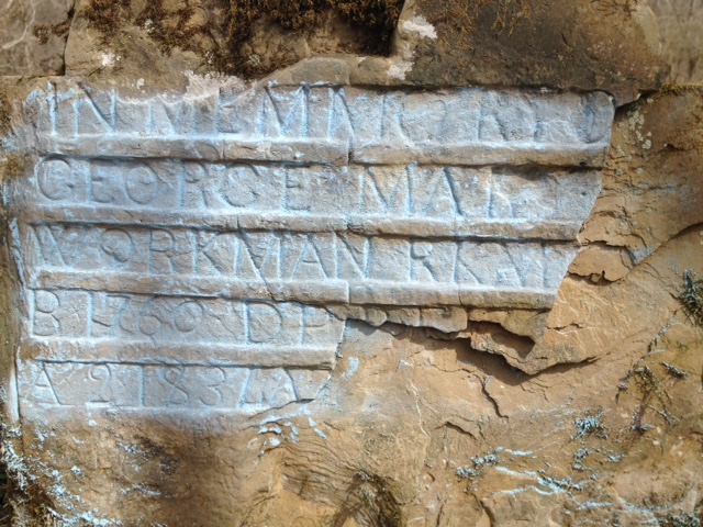
In many places, the Earth depressed downward, a tell-tale sign there is a grave, but no stone marker of any type present.  A few larger stones are propped against stone formations, apparently shielding the shallow graves from animals or other facetious individuals.  The grave stones are worn and many are illegible, but the ones that are legible are from the late 18th and early 19th centuries with surnames of Hawkins and Workman; undoubtedly early settlers in this area of Bath County.  I couldn't help but feel a sense of sadness for these souls who lay beneath me; their stories are forgotten to the ages.  I hope that there are ancestors out there still living that can trace back and know who these people are.

A crypt vault or cellar?
As I walked through the cemetery, I saw what appeared to have been walls of some sort.  One area looked like it had been a quite large structure of some sort, with only foundation walls left, but upon further inspection, I noticed a few grave stones within the walls.  These must have been family plots and the outlying boundary markers.  Another pile of rocks lay scattered around another larger walled structure, but no grave stones were noticeable.  I wondered, could this be the remains of the Old Republican Meeting House or Stone Fort?  Looking at the area in full view showed two stone arched door ways buried in the ground with only about three feet visible.  What I was seeing was a roof of some type of crypt or other structure meant to be closed off to the outside world.  It would be interesting to see just how much of this is underground now and what it once was. The spur of the moment trip on that Sunday afternoon had been well worth the drive there. As I was driving away, back toward home, I glanced off the side of the road and spotted the remains of a large two-story house made of rock.  There was no roof on it and it was practically hidden in the trees.  The structure is on private land and a mobile home sits on it, so I dared not just walk up to the site without permission.  I think I may have found the meeting house or maybe the block house that was known as the Old Stone Fort.  Another trip and land owner permission is definitely a plan.

I left the cemetery with a sense of sadness and intrigue to know more about these souls.  A trip to the library will be soon, to try to locate what I can about this sacred ground I stood upon.  The pictures I took don't give a full appreciation of the old cemetery.  Of all the stones there, I could only make out the following:

-John Hawkins, dates of birth and death unknown, however, the unknown name sharing the same stone faintly has a date from the 1700's on it

-George Workman, born 1760, died 183?

-Elizabeth Hawkins, born 1739, died 180?

-Chrsitian Wayra?, died 6 Jan ?.  This grave is pictured in John Richards' book and the inscription says "Christian Wayra?, died 6 Jan 1802 A 100", but it has since faded away mostly.

Below are more pictures I took of the Old Republican Meeting House Cemetery:


Unknown inscription
Remains of a possible burial crypt or cellar

A damaged burial crypt

Another view of the crypt/cellar that is partially buried


A walled gravesite

Resting place of John Hawkins

Moss overtakes what man has carved

An unknown soul

Another illegible inscription

A quite large burial crypt

Walls bordering some graves


George Workman, born in 1760

Elizabeth Hawkins' grave states she was born in 1739

A lonely, unknown grave marked by only a single rock

Maybe someone who reads this will know more about this old cemetery and the people resting there.  Maybe, too, someone will be able to close a genealogical gap in their family's story as a result of my Sunday expedition.  And maybe, just maybe, these souls and the history of this once important area will live on in some way.


***A Follow up, January 29, 2015:  Fellow history buff and news editor Cecil Lawson recently drove out to the cemetery site and sent a picture of the old stone house I saw.  I also found a drawing of what the Old Stone Fort looked like that was in a publication the Bath County Chamber of Commerce released in 1961 for the 150th  anniversary of Bath County.  Based on the location and the pictures, we are confident that the old stone house in the woods is in fact the Old Stone Fort.  It looks as if it was indeed a large house built similar to Morgan's Station near Mount Sterling.  The house has fallen in from what we can tell, and we are working on getting permission from the property owner to inspect and photograph this historical site before the environment reclaims what's left of the house.

Illustration depicting the Old Stone Fort, courtesy of the Bath County Chamber of Commerce, 1961

The Old Stone Fort, 2015, courtesy of Cecil Lawson
 
***A Follow up, July, 2015***

After reading this blog, local historians Richard Oldfield, Don Johnson and Ken Darnell explored the Old Republican Meeting House Cemetery and were able to clean some head stones and recover some of the names previously unseen.  Here are some pictures they took that day:


On Memorial Day weekend, 2015, I took my sons to the site of the Old Stone Fort and took a close up picture of the ruins:


Wednesday, December 31, 2014

Another Year Passes

It's hard to believe that another year has nearly passed us.  The fourteenth year of the Twenty-First Century has been a year mixed with joy, fear, triumph and disaster; but if one looks back throughout history, it has been a rather typical year.  I look at the things that happened nationwide and I see strange parallels from the 1960's; the racial divides, the riots, the protests, the call to arms by those who want their voices heard.  Fortunately, Bath County has been spared these major events and we hope to continue being kept away from that microscope of life.  

Some great things happened this past year in Bath County; probably the most important being the expansion of the food processing plant in Owingsville's Industrial Park.  That expansion brought around 300 jobs to our community and has boosted our local economy, if you look at the whole picture rather than seeing just the paper backing.  Our community spirit has started to flicker again with our May Day Celebration, Court Days, and even our town pep rallies for our athletics programs being widely supported by the people.  It was twenty-six years ago that the football team closed down a block in Owingsville to celebrate a great season (one I am proud to have been a part of) and seeing that interest again during the Homecoming Parade this year should make anyone smile with pride.  

There have also been tragedies and losses this past year.  The Owingsville Fire Department, of which I am Assistant Chief of, responded to a record of over 300 calls in 2014.  There was a time when we responded to maybe 100 calls in a year and thought we had really been busy.  The calls we responded to haven't all been easy; in just the first three months of 2014, we lost two local men in residential fires.  One man was rescued, but succumbed later and the other was found in the burned out debris of his home.  We worked many automobile accidents where property and sometimes lives were damaged or lost.  I worked a call where someone I had known many, many years lost his life due to a motorcycle accident.  Many other prominent and well known people in Bath County passed away naturally, leaving their history to be carried on by loved ones or people who knew them well.  I hope their stories never fade off into oblivion.

Has anything truly historical happened in Bath County that would be talked about in years to come?  That depends on what a person's idea of historical significance may be.  It could be the building of the local economy and development, the closely watched elections we had, or something that others may deem insignificant.  However one looks at it, the fact is that 2014 is now marked in the books of history.  I would like to take this moment and thank each and every one of you who has read my historical reflections about Bath County.  It has been truly overwhelming to see nearly 6,000 people from not only the United States, but from all over the world, taking the time to read these chapters.  A huge thank you to Cecil Lawson and the Bath County News Outlook for publishing my stories so those who may not be cyber-connected may enjoy them.  I plan on continuing to bring you these glimpses of our history as long as I am able; who knows how many more chapters are to come..
.we will just have to wait and see together. 

Happy New Year!

Tuesday, November 11, 2014

A Veteran's Day Salute to Sergeant Lewis Ensor

Today is Veteran's Day, 2014 and I salute my great-uncle, Lewis Ensor.  Here is just a part of his story.


Sergeant Lewis E. Ensor, Company K, 148th Infantry, 37th Infantry Division, Pacific Theater of Operations 1941-1945


 I was soldier returning from duty in the Persian Gulf and took a trip with my dad to a hilltop overlooking his home town of Sherburne.  Atop that hill, his uncle, Lewis Ensor, lived in a little white farm house that gave a commanding view of the Licking River Valley below.  I had been to Lewis' house many times and talked with him quite often as I ate lunch at the Sherburne grocery store while on break from working on nearby farms, and I always knew he was a combat veteran.  He never really talked about his service until that day dad and I visited.  But first, a little background on my great uncle.

Lewis Ensor was born on May 4, 1918.  He was raised in the Bethel and Sherburne areas of Bath County and worked as a farmer.  He and his family had plenty of struggles as Lewis grew older, but they remained close and humble.  He entered his military service in 1941 as an infantryman and eventually became part of the 148th Infantry, 37th Infantry Division.  The 37th would take Lewis Ensor halfway across the world and into the mouth of Hell.

As dad and I sat in the living room, Lewis stood up and told me, "I have some stuff to show you".  He retrieved an old box and sat it down on the table in front of us.  When he opened the box, I saw a pile of old, black and white photographs depicting soldiers in battle and some of the horrors involved.  As he picked the pictures up, he started talking about the scenes unfolding in the paper.  For the first time, my great-uncle was opening up about the war.  He showed me group pictures and identified specific people; telling me who made it through the battles and who didn't.  
"We had to kill those Japs", he said.  "We had to kill them or they'd kill us.  If they didn't shoot us, they would sneak in our foxholes or tents and slit our throats while we slept.  So we had to kill them.  It's what I had to do."  I could see in his face that he was very passionate in what he was telling me, but also was trying to justify what had to be done for survival.  

Lewis told me about one incident on Bougainville Island where his men were pinned down by gunfire coming from a Japanese gun emplacement on a hill above them.  Soldiers couldn't move one way or another, nor could they emerge from their dug in positions without being cut down by the machine gun fire.  Mortar rockets rained down all around them as they fought to survive the carnage.  A slight lull in the machine gun fire gave a slight advantage to the men of Company K, 148th Infantry and a break was found in the Japanese flank.  Lewis and a couple of men were ordered to seize the moment and take his mortar and rockets through the flank and try to knock down the enemy gun emplacement.  He told me they had to crawl most of the way to keep from being cut down and when they finally secured a location, he and his men sat up the mortar and launched rockets into the enemy position.  The intense firing was halted when the enemy position was destroyed by the rockets of Lewis' mortar and the men pinned down were able to advance and secure the hill finally.  I sat there listening to him recount this; the look in his eye was wandering into a steady stare as the moment flashed back into his mind and out of his mouth.  I was in awe, but dad was even more in awe as he had never heard this ever before.  That was just one incident of Lewis' experiences, the only one he really told me about in detail. One thing he told me that will always stick with me is that they were "wore out, bloody, running low on hope and ammunition" when he looked up and saw the American flag waving on a hill above them.  "That flag gave me and my guys the feeling that it was going to be alright, and it was", he said in a low voice.  As we wrapped up our visit, Lewis told me, "Now when I'm gone, I want you to take care of all this for me".  I told him I would and we left.  On the way home, I was curious to find out just where all Lewis had been, but in 1993, the advent of the world wide web was in its infancy and I had to report back to Germany soon after.  My research plans got put on hold for a number of years.

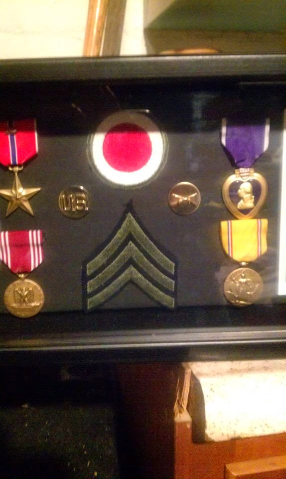
Some of Sgt Lewis Ensor's awards
Fast forward to 1998.  My great-uncle Lewis Ensor was in failing health and dad helped him out by making it possible for him to live closer to us in the senior apartments in Owingsville.  The once strong man who had fought off the Japanese so boldly had become ridden with arthritis and was frail.  In the early 90's, Lewis had a recurrence of malaria that he had contracted in the jungles during the war, but recovered after a few weeks, but he was far more frail this time.  Eventually, Lewis had to move to a residential care facility in Owingsville and eventually passed away on July 16, 2001.  I kept my promise to him by taking the box of pictures and other items such as foreign money, military instruction manuals and other mementos he had kept.  Among the items were a few award ribbons and his discharge papers.  For the first time, I could really see what all my great-uncle had accomplished as a soldier.  Another document I found was the award citation for a Bronze Star Medal that detailed his account of the fight for the hill on Bougainville Island he told me about.  Dad and I noticed that some of the ribbons Lewis should have had weren't there.  Also missing were his medals.  After a few phone calls and some help from Danny 'Greasy' Belcher, we were able to get Lewis' medals and other awards.  I had no idea how decorated he was; two Bronze Star Awards, a Purple Heart, Combat Infantry Badge, among other awards. 

The red and white patch is the 37th Infantry Division's unit patch
About two years ago, I decided to take Lewis' medals and display them in a case.  While doing that, I researched the history of where my great-uncle served.  His infantry division was deployed into the Southern Pacific as part of the 'Island Hopping' campaignHe was assigned to Company K, 148th Infantry, and saw action in New Guinea, then at Bougainville in 1943.  He and his unit moved through the Solomon Islands and onward to the Philippines.  Lewis participated in the Battle of Luzon in the Philippines and was wounded in combat; hit by a bullet and piece of shrapnel that lodged in his jaw, leaving a scar he carried with him.  Lewis returned to duty but faced no further direct combat after he recovered from his injury and was discharged in 1945 as a sergeant. His display case is sleek and an oblong rectangle to accommodate his funeral flag dad has kept. It is a fitting tribute to a man who came from humble beginnings and was thrust into manhood as a combat infantry soldier.

I look at all the men and women who served our great country and sometimes think to myself, "wow, I'm part of them."  Hearing veterans talk about their experiences in combat makes me ever so grateful for their service and sacrifices both emotionally and physically.  I, too, am considered a "combat veteran" but don't see myself as such.  I did not see the horrors of war, I didn't rush through a hail of bullets to save a fellow comrade, nor did I march triumphantly into Baghdad like others who followed me.   My 'combat' tour was during a cease fire contingency operation post Desert Storm, and is nothing comparable to what the soldiers in World War II, Korea, Vietnam, the tank battles of the Saudi Deserts, Iraq or Afghanistan have seen.  I call my tour of duty the 'push button war'.  I have friends and people I watched grow up around me come home from the modern day wars fought who are enduring post-traumatic stress and aren't the same as they were before they went off to war.  It used to be an honorable thing to say to a returning veteran, "welcome home", but maybe we should add, "how are you doing? I'm here when you need me" to that greeting.  My great-uncle's story is just one of many, many others who served, and I was lucky enough to hear him tell it in person.  If your loved one is a veteran, be it combat or peacetime duty, let them know they are appreciated for their service; not just once a year, but every day you have with them.

Carry on, soldier...
 Sergeant Lewis E. Ensor, US Army
K Co., 148th Infantry, 37th infantry Division
Term of service:  1941-1945
Pacific Theater of Operations
Solomon Island Campaign, Battle of Bougainville & New Guinea
Battle of Luzon, Philippines

Awards & Decorations:

The Bronze Star Award with one Oak Leaf Cluster
 The Purple Heart
Army Good Conduct Medal
American Defense Medal
American Campaign Medal
The Asiatic/Pacific Campaign Medal with two bronze campaign stars
World War II Victory Medal
Liberation of the Philippines Medal with one bronze campaign star
Combat Infantry Badge
Rifle Marksmanship Badge
Army Lapel Pin