Thursday, December 17, 2015

Founding Fathers

To build a good house, you must first build a good foundation, as the saying goes.  That foundation must be able to stand and bear the weight of the entire structure, but it takes a visionary to plan and build that foundation.

Bath County

When Kentucky was known as the "far west" during the English colonization period, it was largely untamed wilderness used for hunting by nomadic tribes of natives.  Around the early to mid 1700's, explorers began trekking into the wilderness and establishing settlements along the Kentucky, Ohio and Licking Rivers.  The land we know as Kentucky was part of Virginia until 1792, and Bath County as we know it was initially Fayette County, then Bourbon and finally Montgomery Counties before becoming the state's 56th established county in 1811.  Kentucky's then governor, Charles Scott, commissioned the first county court of Bath County, consisting of Thomas Isles, Jacob Sorency, John Hawkins, Paul Skidmore, Elisha Owings, Josiah Richards, Francis Hopkins, William Donaldson, Issac Gray, Andrew Gudgell and James Blair. The first county court meeting was held February 25, 1811 at a home on Flat Creek belonging to James Young.  James McIlhenny was commissioned by Governor Scott as being the first Bath County Sheriff, Thomas Fletcher was commissioned by the Court of Appeals to the title of County Clerk and James Hughes as State's Attorney.  James Young was appointed Jailer and Joseph Dawson appointed Coroner during the same session.  Abraham and John Thompson, William Hughes, Spencer Boyd, George Routt, John Arnett, Robert Mitchell, Edwin Oakley and John Alexandra were also appointed as the first county commissioners of the newly formed county, rounding out the core government.  These men were the foundation of Bath County; others who came after solidified that foundation by establishing other vital communities within the county.


Owingsville


Thomas Deye Owings
Jacob Myers, a German immigrant, traveled from Baltimore, Maryland into what is now Bath County in 1782 and patented over ten-thousand acres of land along Slate Creek.  He had heard talk of rich iron ore deposits in the area and once the claims proved to be true, he and Christopher Greenup started constructing the Bourbon Iron Work.  In the meantime, John Cockney Owings, a wealthy businessman from Cockneyville, Maryland, purchased around seventy-thousand acres of land in Bath County that included Myers' tract where the iron furnace was being constructed.  The first blast of the iron furnace was in 1790 and in May the following year, the operation was purchased by John Cockney Owings & Company.  Owings sent his son, Thomas Deye Owings, to manage the Bourbon Iron Furnace operations in 1795.  Thomas Deye and his family resided in Lexington, Kentucky after his relocation and obtained full ownership of the iron works after the death of his father in 1810.

A small settlement near the Bourbon Iron Works known as Catlett's Flat was established as the original seat of Bath County shortly before the county's formation. Around the same time, a notable Irishman named Richard Menefee moved from Virginia and purchased land adjoining the Owings tract.  It was decided that the county seat be relocated atop the hill that dominated the area, partly due to the strategic location and easy defense along access roads, but mostly due to the number of prominent families who were starting to settle there.  Both Owings and Menefee offered to donate a portion of their land to create the new county seat, but only if the new settlement would bear the name of the donor.  To settle this, the two men decided on a friendly wager; the one who could build the most luxurious home in the shortest amount of time would have the honor of naming the new town.  Between the two tracts of land, approximately 200 acres was set aside for the new seat.  Menefee began construction of his home on property he owned along what is now West Main Street, approximately in the location where the Bath County Middle School now sits;  Owings' home would be built about half mile east of Menfee's.  The men spared no expense in building their homes and Owings hired renowned architect Benjamin Latrobe of Washington, D.C. to design his residence; it is unknown if Menefee hired any such architect to construct his home.  Thomas Deye Owings' house was the first home completed in 1814 and was the lap of luxury for the time.  Menefee conceded to the terms of the wager, thus the new town would be called Owingsville.  The Owings House is a massive three story structure with a magnificent free standing spiral staircase as it's center piece attraction.  The walls are made of brick twenty-four inches thick; almost fortress like with heavy wooded shutters to close the windows tight in the event of an Indian attack.  The exterior looked much different than it appears today and was described in An Illustrated History of Bath County as "severely plain...a rectangular plan of 75 by 52 feet". Richard Menefee's home was a brick structure and probably very elegant, however there are few records regarding what the home looked like.  The Menefee home stood for many years, but disappears off plat maps sometime around the Civil War.  Thomas Deye Owings died October 6, 1853 and is buried in Brenham, Texas; far away from his namesake town.  Richard Menefee died in August, 1815 and his burial location seems somewhat a mystery; quite possibly in the cemetery that lies beneath the parking lot behind the People's Bank at the corner of Slate Avenue and Coyle Street in Owingsville.  While Menefee may not have had the honor of a town's name, neighboring Menifee County bears his family's surname, albeit misspelled.  Thomas Deye Owings can be credited as the town's namesake, but both he and Richard Menefee should be credited as Owingsville's founding fathers.


 Sharpsburg

Moses Sharp was born in Virginia May 2, 1757.  He served a three year term in the Virginia Militia during the American Revolutionary War under several different commands and campaigns.  He was honorably discharged after Cornwallis' capture in 1781, and by some reports was at Valley Forge his last duty station.  After the war, returning veterans were able to obtain land grants in Kentucky for settlements.  Sharp moved to Kentucky sometime around 1787 and settled in the northern section of what is now Bath County.  It is said that he worked as a spy for Daniel Boone at the time of his move, but to what extent remains a mystery.  At the time, the area in northern Bath County was mostly forest with open grasslands filled with native flowers, and Sharp was so inspired, that in 1814, he laid out a plat for a town in which he would call Bloomfield.  Moses Sharp and his wife, Mary, reared eight children and established a farm on his land just north of the present day town.  Sharp died in 1820, and soon after, a post office was established in Bloomfield.  Bloomfield's name was changed around 1825 by the town's postmaster due to another city bearing the same name; that name, Sharpsburg, would honor the man who founded the town.  Sharpsburg remained a quaint, but thriving, little town, with several merchant shops lining the business district.   The town was along the Maysville/Mount Sterling turnpike and was along the vital stage coach route that ran to the Ohio River.  Today, Sharpsburg still thrives as a small town, with agriculture being the primary industry.  Many descendants of Moses Sharp still reside in the area and some their farms have been passed along over many generations of the Sharp name. Moses Sharp's burial location is in an overgrown section of land known as Goodpaster's Field between Ramey and Ratliff Roads just outside of the town that bears his name.  Take a look at the site http://www.pbase.com/jtsmall/sharp_cemetery to see the location and a restoration effort to the Sharp Cemetery.


Bethel

The town of Bethel was first platted around 1817, but the founder's name has sadly been lost to history.  The vast, fertile fields on the ridges and valleys along the Licking River and Flat Creek attracted farmers to this area of Bath County very early in Kentucky's history.  Settlers began moving into the area in the late 1700's, along Flat Creek's banks.  The Old Republican Meeting House was located along what is now Sanderson Road, just down from where Bethel would be established.  A cemetery close to the spot of the old meeting house bears several interments with the Hawkins surname, so it is a fair assumption the Hawkins family were the first inhabitants of the area.  A large house constructed of limestone was situated along a tributary stream of Flat Creek and used as a 'fort' against Indian attacks; the early records show this house was built in approximately 1791.  The remains of this house are still standing on a farm near the Old Republican Cemetery.  After Bethel was established, a police judge and officers were commissioned to keep the peace, but their names are not known.  Lucy Harper spoke at the dedication of the new school building in 1924 and stated, "I cannot find a record of the early history of Bethel, but tradition tells that the first building was an old log church situated in the old cemetery".  Ms. Harper then stated that the church was named Bethel, or "House of God" and that the town's name originated there.  During the Civil War, rebel guerrilla forces stormed the town and burned most all of the old records, erasing the early documented story of Bethel.   

Salt Lick

The story of Salt Lick begins with a group of pioneers who explored the Licking River down to Salt Lick Creek around 1771.  These explorers, Simon Kenton, George Yader, and John Strader, were possibly the first white men to ever explore into what would be Bath County.  The southeastern area of the county where Salt Lick now sits was a vast, heavily forested region of rich hardwoods and had several natural mineral and salt deposits where buffalo, bison and other animals gathered.  A few people settled here and there during the early to mid 1800's, one being Lafayette North who settled on 700 acres after his service in the Mexican-American War around 1848.  Around 1882, a town then known as Vail was platted out along the newly constructed Chesapeake & Ohio Railroad and James Colliver established the post office.  Vail, according to the Kentucky State Gazetteer and Business Directory published in 1884, boasted a population of fifty, a saw mill and four general stores.  Sometime around 1884, the town was renamed Salt Lick, but the post office retained the Vail name until 1888. Salt Lick became a booming industrial and shipping hub and remained prosperous until well into the Twentieth Century, mostly due to the abundant resources and trains that rolled through.  It's not known who exactly the founding father of Salt Lick was, but a number of family names from that early period still appear today; Dickerson, Maze, Shouse, Razor and Staton are a few examples.

Other communities

While Owingsville, Sharpsburg, Bethel and Salt Lick are the most established towns in Bath County, many more communities were founded.  The oldest place was the settlement called Yale, first settled by Samuel Gill around 1807-08.  It was there that Gill constructed a mill and over the next several years, the settlement became a boom town of sorts.
The long gone town of Yale
Yale would boast hotels, a saloon, a post office, several merchant shops, a railroad, and a population of around three-hundred in its hey-day.  Wyoming was a town situated at the confluence of Slate Creek, White Oak Creek and Licking River.  It was founded in 1820 from land that belonged to Thomas Deye Owings, and originally called Mouth of Slate.  The first true proprietor of Wyoming isn't known, but the county court appointed Jacob and John Trumbo, Isaac Conyers, Archibald Ramsey, William Atchinson, Phillip Clark and Coleman Smoot as the town's original trustees soon after it was surveyed in 1819.  Today, nothing is left of the once thriving towns that were Bath County's earliest industrial hubs; Yale is now under Cave Run Lake and Wyoming was bypassed by the modern age. 

Moore's Ferry, located on Kentucky 211 north of Salt Lick, was named for a man only known as Mr. Moore, who established a ferry across the Licking River to Grange City in Fleming County.  In the same vicinity, William Isles settled sometime in the early to mid 1800's and established a mill along the Licking River.  The mill was successful business and a hotel was established to accommodate those who had interest in the mill operations.  The mill ran until 1912 and the log dam across the river was dismantled soon afterward.  Today, the only trace of the old mill is the name of the road that led to it.

The southwestern portion of Bath County was settled very early by pioneers such as Peter Cassidy, who established a fortified station in the Saltwell and Stepstone area of Bath County in 1777.  Others who settled along with Cassidy found a salt well that had been walled with stone; however there is no mention of who may have constructed the well.  Kendall Springs was first settled around 1815 by Ransom Kendall who built a cabin next to an abundant well located near what used to be Carpenter's Store at the corner of Ely's Branch Road. The location of the spring was probably well known to the natives before the settlement was established, as it was an area known to be along an important hunting path.

 The town of Olympia was laid out sometime between 1876 and 1884, but it is not known who founded it.  Old precinct maps from those dates show a few houses and structures; however, the maps prior to 1876 show a sparsely populated area. The famed Olympian Springs Resort was located a few miles south of the town and was first opened by William Ramsey around 1796, long before the birth of Olympia as a town.  When the C&O railroad was constructed, Olympia Station
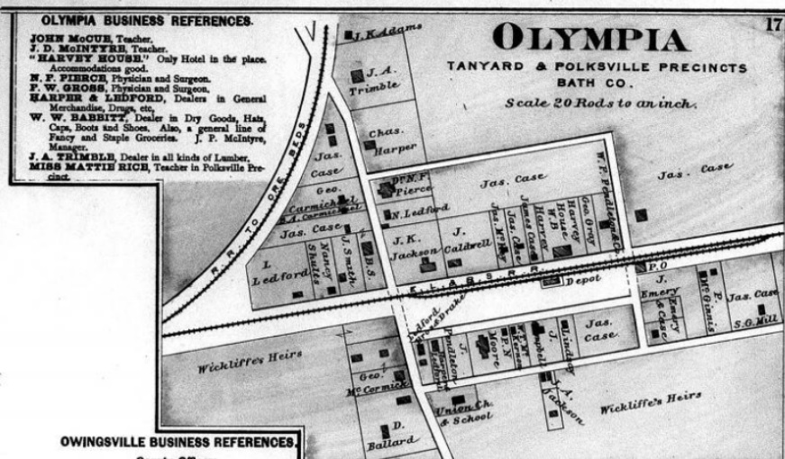
Olympia, 1884. www.historicmapworks.com
was established and connected the narrow gauge rail lines that ran to the nearby iron ore mines.  The date of this establishment was around 1883, giving an approximate date of the town's birth.  It is known that Cal and Riley Ingram had purchased an extensive amount of land and leased it about this same time.  They operated a couple of saw mills along Mill Creek and used the railroad to ship their timber; quite possibly the first proprietors of Olympia.

Preston was founded in 1881 as Preston's Station for William Preston who donated property for the C&O railroad.  The post office was established shortly after, but named Crooks after a prominent family who resided in the area.  Later, the town's name changed again to simply Preston, and was a regular stopping point for passengers and freight along the railroad line. Over the years, Preston has retained that small town feel and hosts the annual October Court Days festival that brings in thousands of people from all over.

Other, smaller communities sprang up throughout Bath County, and are still known today.  Wes and J.S. Blevins settled just outside of Preston around 1900, purchasing tracts of land and building some small homes.  The Carter family moved in the area soon after and a community was established, known as Blevins Valley.  Polksville was laid out and established in 1844 by Robert Warren, naming it after President James K. Polk.  The post office there was called the Marshall P.O. and there was a general store, blacksmith, school, church and a population of about fifty in the early days.  Reynoldsville was named for Joseph Reynolds, a doctor from Virginia who built the first home there around 1870.  Many more small hamlets dotted Bath County's landscape but were never officially established as towns or they were absorbed into larger communities.  Each of these settlements and towns have a history and story to tell on their own. Those who blazed the wilderness trails, laying the cornerstones and foundations of the communities within Bath County, left a lasting legacy for all generations.  

Resources:

www.historicmapworks.com

An Illustrated History of Bath County, John A. Richards

http://www.wtblock.com/wtblockjr/thomas_deye_owings.htm


Friday, November 27, 2015

In the Days of Iron Horses: Bath County's Railroads

While coming home from a recent business trip, my work colleague and I stopped in the Western Kentucky town of New Haven and visited the Kentucky Railroad Museum.  Outside the museum is a large train and some cars on display that bear a familiar moniker to many local folks; Chesapeake & Ohio.  For those who remember the days of the Iron Horses that ran through Bath County, and those who have yet to discover, this is the story of the railways that once crossed the fields and through our small towns.


Not long ago, about thirty-five years ago to be exact, the distant howls of an early morning steam whistle echoed through the valleys, bouncing off the hills and mountains along the way as I stood outside waiting on the school bus.  From my vantage point, the sounds were coming from a southeastern direction toward Polksville, and was the train that passed daily from Olympia to Salt Lick along the Chesapeake & Ohio railway.  I was fascinated when I saw the mighty trains pass along the way while traveling with my family, but had no idea at that early age the importance and impact these machines made to thousands of people over time.


Bath County's rich natural resources were harvested or mined, then traded by people long before the advent of modern travel.  Natives traded furs and food among themselves and with the occasional pioneer trader as they passed on horseback or by foot.  Early settlers used mule, ox, or horse drawn carts to move goods across the mountain passes and fields to river towns where the items would be placed on flat boats and sailed down the Licking River to the Ohio River ports in Maysville.  The abundance of timber along the Licking River in the southeast region of Bath County gave rise to thriving settlements called Yale and Ragland Mills, while the iron ore and mineral deposits in the central part of the county spawned booming iron smelting operations.  At the time, cart and river travel was a long, tedious and sometimes dangerous journey; terrain, weather and encounters with Native Americans caused delivery of these goods much delay.  Passenger travel at that time was by stagecoaches along dusty, bumpy and sometimes very treacherous paths that also took long periods of time.  One of Kentucky's first stagecoach lines ran from Lexington to Olympian Springs, along the wooded paths that passed through Mount Sterling and Winchester.

The first railroad to operate in Kentucky was the Lexington & Ohio Railroad, built in 1832-1833.  It ran from Lexington west to Frankfort, with substantial financial backing to continue onward to other points along the Ohio River.  In 1852, the Lexington & Big Sandy Railroad connected the heart of Kentucky to the state's eastern coal fields and beyond to the eastern seaboard.  The proposal for railroads through Bath County was brought to the table for voters to consider in July, 1852.  A purchase sum of stock worth $150,000 in the Lexington & Big Sandy, or L&N, Railroad was required for the creation of the rail system.  The vote was 854 in favor, 408 opposed.  In April, 1853, Bath County subscribed to the stock at $1,000 each, payable in thirty years at six percent annual interest.  The stock was payable bi-annually through the Bank of North America, housed in New York.  By 1876, twenty-two of these stock certificates were bought, then retired.  The remainder of the balance then went to a financial institute in New York and the county refused to pay any further interest.  A lawsuit resulted against Bath County, with judgement awarded to the plaintiff, Amey & Company.  Bath County Judge E.V. Brother negotiated a settlement sum of approximately $234,000, of which Amey & Company agreed to reduce another $25,000 off the debt.  Bath County paid a little over $31,000 back, with a remaining seventy-five bonds sold between 1880 and 1886; the last finally paid off twenty-five years later under the administration of County Judge Executive C.W. Goodpaster.  Because of this, the railroad project was derailed for some time.

Proposed map of the Elizabethtown, Lexington & Big Sandy Railroad, 1853
On January 29, 1869, the Elizabethtown, Lexington & Big Sandy Railroad Company was established by an act of Kentucky's legislature, consolidating with the Western Division of the Lexington & Big Sandy Railroad.  The Chesapeake & Ohio Railroad was formed in 1869, incorporating several smaller rail lines from Richmond, Virginia to Huntington, West Virginia by 1873.  These rail systems would further link Kentucky to Atlantic sea ports, and provide much needed jobs for the post Civil War population.  Around the same time, small, narrow gauge railroads were being established in the coal mining towns in east Kentucky, Virginia and West Virginia.  The smaller locomotives were economical and could easily access narrow mountain passes along the way.  The Elizabethtown, Lexington & Big Sandy railway began construction in 1871, linking Lexington with Winchester.  By June, 1872, the railway was extended to Mount Sterling and stopped there due to lack of funding.  Plans were drawn out for the railroad to pass through Owingsville and sites were surveyed and mapped as early as 1853.  Right of ways were purchased, then abandoned, and eventually Owingsville was passed up as a train stop location.  In 1892, the EL&BS Railroad was bought out by the Chesapeake & Ohio Railroad Company and construction began connecting Huntington to the heart of Kentucky.  Meanwhile, between Yale and Ragland Mills, a three-foot narrow gauge railroad was starting to to be established to transport timber to ports along the Licking River.  Chartered by the Sterling Lumber Company in 1896, the Licking Valley Railroad came to life in April, 1897.  The rail line ran from the lumber mill at Yale to Ragland Mills, and onward twelve miles to Salt Lick, where it eventually connected with the Chesapeake & Ohio line.  The Sterling Lumber Company failed and dissolved in 1899, leaving the railroad up for purchase.  Yale Lumber took ownership of the mill and purchased the railroad for $29,000; renaming it Licking River Railroad.  In addition to freight hauling, a passenger service was established to generate much needed revenue for the railroad.  By 1905, the Licking River Railroad expanded into Morgan County to Blackwater, encompassing a total of thirty-five miles.  A total of thirteen Climax type locomotives
Photo courtesy of www.gearedsteam.com.
operated along this route with five freight boxcars; a significant amount for such a small line.  A single passenger train ran daily from Yale to Blackwater, then to Salt Lick and back to Yale.  As the early Twentieth Century dawned, the intense logging operations began to deplete the forests at a rapid pace.  Native hardwoods became nearly obliterated and the lumber yards began to reduce operations.  By 1906, the Licking River Railroad became unprofitable due to the people leaving the area to find better work, and by 1913, the little railroad was abandoned.  The tracks were pulled up, the trains and cars were sold off; however, one locomotive, some cars and most of the rails remained in Bath County and moved to Owingsville.  A couple of other narrow gauge railroads sprang up during this era; one being used primarily for transport of iron ore at the Rose Run Iron Beds between Polksville and Olympia.
These rail systems utilized rail carts and horse drawn wagons to transport ore to markets in the area and were short in length; thus no regular freight or passenger service was ever established.

Rose Run iron mining operation in Bath County,
mining from Brassfield(Clinton) iron ore beds.
Photograph by A.M.Miller, 1919
As the railroads expanded, the vision of a standard rail system through Bath County was finally a realization.  Construction began from Mount Sterling into Bath County in 1880, with freight depots built in Olympia, Preston, and Salt Lick.  A connector line was  proposed to run from Owingsville to Sharpsburg around 1886 when the Paris, Georgetown and Frankort Railroad was established.  The line would also connect Owingsville to Salt Lick and down the Licking Valley line to Yale.  Bath County would own and maintain the railroad, of which the county raised $2000,000 in bonds at 5% interest.  Additional principle would have to be borrowed from private sources solely on the good faith that the rail service would be prosperous.
An 1888 pamphlet published by  F. L. McChesney, of Paris, entitled The Kentucky Midland Railway Company – Its Resources and Prospects said this about the PG&F Railroad route:
   “Starting from Frankfort, the Capital of the State, a prosperous city of from 8,000 to 10,000 inhabitants, and one of the largest lumber markets . . . . proposed road will pass eastwardly . . . through Stamping Ground . . . . Georgetown is reached, a flourishing city of 3,000 inhabitants . . . . Here a junction is made with the Cincinnati Southern, opening to that road the most direct line to Frankfort and to Louisville.  The Kentucky Midland will certainly divide the business south of its line with the Lexington branch of the Louisville & Nashville, and will also receive the entire traffic north of its line where there is no competing road.”“Traversing a magnificent section of Bourbon county, the road will reach Paris, a growing and enterprising city of between 5,000 and 6,000 inhabitants.  The business of Paris is large . . . . the most important shipping point on the Kentucky Central Railroad.”
“after passing through Bourbon the road will enter the county of Bath within about one-half mile of Sharpsburg . . . . the farmers are well-to-do, and almost all have deposits in their local bank.”
“The road will pass through Owingsville, a prosperous, thriving, business town.”
“The Kentucky Midland will cross the Chesapeake & Ohio near Salt Lick, and thence will pass on through Morgan county.  Near Salt Lick it will reach and cross the Licking river, and open up a large lumber trade.”
“In Morgan county, is the best defined and most reliable and largest cannel coal field in the known world.”  
The PG& F route through Bath County would run from Paris to Sharpsburg, onward to Owingsville near the courthouse square, crossing the C&O Railroad at Salt Lick, then to Yale.  During construction, the railroad's route shifted and the route into Bath County never went beyond the planning phase.  The railroad instead went from Paris to Carlisle onward through Cynthiana, Falmouth, Maysville and Covington.  During the expansion from Paris, the railroad's name changed to the Kentucky Midland Railway.  A couple of other proposals from interested parties came to light in 1896 and 1897, with one route running from Jellico, Tennessee through Owingsville to the Ohio River, but neither proposal came to fruition.   A new rail line from Midland to the mouth of Caney Creek, near the Caney Furnace location, was also proposed, but never got past planning.  An electric railway was proposed by John P. Martin of Xenia, Ohio to run from Mount Sterling to Sharpsburg, carrying freight from the Cincinnati-Southern Railroad, but again, never came to be.

As the Twentieth-Century arrived, the towns of Olympia, Preston and Salt Lick became booming industrial ports for the railroad, which, in 1904 was consolidated and changed from the Elizabethtown, Lexington & Big Sandy to the Chesapeake and Ohio Railroad.  The railroad was especially important to Salt Lick; a large lumber operation was established on the southern outskirts of town. 
Coal Burning Train, Salt Lick Ky. 1900
Many local men were hired by the railroad as linemen, signal operators or performed other essential duties to maintain the rail line.  Owingsville, however, would be largely ignored by the railroad systems.  From 1907-1909, there was an interest in getting rail service from Salt Lick, through Olympian Springs, Owingsville and Sharpsburg, ending in Maysville.  Many prominent people of the day expressed a great interest and public meetings were held to generate support and potential financial backers.  It was estimated that the route would cost around $400,000, of which many of the county's businessmen were initially willing to help fund.  Engineers and surveyors from the Kaufman-Shaw Construction Company were hired to plot the route and land owners were contacted about right of way, but, like the several proposals before, the idea lost interest.  The Kentucky Midland Route was planned to run from Salt Lick to Paris, through Owingsville, but abandoned early in the planning stages.  The last consideration for Sharpsburg to gain a railroad was in 1909, when the Commercial Club of Winchester proposed a route from North Middletown in Bourbon County to Sharpsburg.  More public meetings were held, and great consideration was expressed, with right of ways agreed upon.  When the proposal was brought before the financial backing group from Philadelphia, the group deemed the railroad as unfeasible, and the project was scrapped.  It seemed efforts to establish an effective rail system in the northern section of Bath County, and into Owingsville, was lost. 
                   
In 1914, the remaining rails from the Licking Valley Railroad were put down in Owingsville to establish the Owingsville & Olympia Railroad, or O&O.  Five cars and a locomotive made up the O&O line, which was also known as the Little Dinky because of the narrow gauge rail and small Climax engine.  The depot was located off what is now Paul Lewis Drive behind the old city hall building on Slate Avenue.  The track ran down the hill, then turned south six miles to Olympia, rounding the hillside across from Kendall Springs Road; of which, the old rail bed can still be seen.  Owingsville had finally secured it's place in the railroad age.  The first train left Owingsville in the early part of 1915 and was managed by W.W. Hubbard, with John K. Richards being the local agent at the depot.  The steam engine soon became impractical, probably due to the steep grade just outside Owingsville, and was replaced by a gasoline fueled engine that could haul the heavy freight and eventual passengers that would board.
A bridge was erected across Slate Creek near the Bourbon Furnace, and is still standing behind the Church of the Latter Day Saints on Kentucky 36.  A couple of smaller trestles were erected over the smaller streams between Owingsville and Slate Creek, one of which was at the bottom of the grade just below the depot.  The O&O was very profitable hauling goods and a passenger service was envisioned, but in October, 1915, ideas for passenger service came to a dashing halt.
The Little Dinky train was parked at the depot in Owingsville taking on freight one afternoon.  Suddenly, the locomotive's brakes failed and the train barreled down the grade.  It continued to the bottom of the hill and raced toward the curve going into the first trestle, gathering momentum.  The train jumped the track at the first trestle and plummeted to the ground onto its side.  The public became apprehensive about traveling on the O&O after the wreck and passenger service eventually came to a stop.  The O&O continued to run freight, but without the funding from passenger service, the railroad became financially unstable.  By 1916, hardly any trains were moving along the route and the Owingsville & Olympia Railroad ceased operations.  The tracks were dismantled in 1918 and sold to coal companies.  No trains have ever rolled into Owingsville since, and the O&O holds the distinction of being the shortest lived railroad in Kentucky.

Salt Lick's depot, circa 1950
The George Washington, circa 1966.
As the Twentieth Century dawned, the railroad system was booming nationwide.  Trains took over the once prosperous river routes and wagon trains that once raced across country.  In Bath County, Salt Lick was the key railroad depot and shipping point.  The town grew into a thriving business district; the rails created much needed jobs for local residents and stores and shops began to line main street in the small town.  In addition to freight, passenger service along the C&O Railroad became routine.  The route could whisk passengers to Washington, DC where they could be connected to other rail lines anywhere up the East Coast.  Steam and coal powered engines still chugged down the lines, but the passenger trains in the early 1900's moved to gasoline power for better efficiency.  Several passenger trains passed through daily, but two were considered the luxury lines of the rails; and made stops at Bath County's local depots.  The first was the Fast Flying Virginian, or FFV for short, which ran the daytime route from Washington, DC to Cincinnati.  The FFV was brought into service in 1889, and was the first train in the Chesapeake & Ohio fleet to have a dining car.  Another amenity was enclosed passages between cars to allow for passenger safety.  The George Washington had air conditioned cars  that provided an extra layer of comfort for passengers on their trip.  The George Washington was probably the most famous of all of the C&O passenger trains due to the level of comfort and scenic views it traveled. Many of the C&O trains were coal burners and rightfully so as the main route ran right through the heart of coal country.  During the Great Depression of the 1930's, the rail system seemed
unfazed by the economic crisis.  The Chesapeake & Ohio line was very prosperous despite the hardships, and helped contribute to the delivery of much needed goods to stricken major cities.  During World War II the C&O trains were one of the main suppliers of materials and men to the ports at Newport News, with many of those trains loaded with war material and recruits passing through Bath County.

During the railroad age in Bath County, there were a few incidents recorded involving accidents and fatalities.  A small article in the Owingsville News Outlook dated February 17, 1898 tells of Jessie Keesee, of Carter County, who was killed by a passing train as he slept near the tracks just outside of Preston.  The Bath County World newspaper notes on the same date of publication that Will Kinsie, also of Carter County, was killed near Preston by a passing freight train; quite possibly the same person, just variations of the name.  Pete Miller of Lexington was killed January 30, 1906 near Preston when the caboose he and another man, Edward Flynn, were operating overturned in a curve.  It was reported that Miller was trapped in the caboose and the overturned stove set the car on fire.  Flynn was badly injured, but survived.  Albert Lewis was killed when he attempted to jump onto a platform between moving rail cars near Salt Lick February 22, 1906.  Another person attempted to jump onto a moving train at the Stepstone freight station, which was located at the bottom of Sugar Grove hill, and was dragged to death in 1908.  A few more incidents of pedestrians being struck are dotted among old newspapers, but perhaps the most bizarre incident is also chronicled in fellow writer Tom Byron's The Kentucky Files blog.  Elbert Thomas of Olympia took a new Greyhound Bus from the terminal yard in Cincinnati one night in July, 1953.  He drove the bus all the way back to Olympia, where he abandoned it in the middle of the railroad crossing on Highway 36.  Shortly afterward, a freight train slammed into the bus, cutting it in half.  No one was reportedly injured in the spectacular crash, but Thomas was arrested and charged with the theft of the bus.

Throughout the early years of rail travel, there were few major accidents involving derailments.  Aside from the Owingsville & Olympia wreck, there was an incident of a Licking Valley train jumping track due to a portion of track being washed out along the route.  Another was the derailment of the caboose that killed Pete Miller.  Two major incidents in the 1970's had the potential for deadly consequences; not only for the rail crews, but to the general public.  A freight train pulling thirty-four cars derailed November 8, 1976 adjacent to a farm belonging to Dick Lyons near the Stepstone freight station.  Twenty-six cars left the track, including a tanker hauling 4,000 gallons of sulfuric acid, tearing out over 500 feet of track.  The damaged tanker car began leaking the hazardous chemical into Stepstone Creek, a short distance upstream from Slate Creek.  The fire department responded to insure there was no fire hazard and the fledgling Bath County Disaster Emergency Services, led by Vernon Barber, responded to assist.  A bulldozer was called to the scene to construct a dam in order to keep the chemicals from further flowing into Owingsville's water supply point, located about five miles away, behind the Lion's Club Park off Kendall Springs Road.  State and railroad emergency response crews arrived on the wreck scene and began using a limestone filter system to neutralize any contaminated water down stream.  Several hours later, the spill was mitigated and the threat was over.  Recovery crews from the Chessie System began moving the train cars the next day and repairing the damaged tracks.  No injuries were reported during this incident, but it was a very close call for the public. 

The derailment at Preston, April 1978.  Courtesy of the Bath County News Outlook
Wrecked rail cars dangerously close to homes after the 1978 Preston derailment
Residents of Preston were going about their usual routines the morning of Thursday, April 13, 1978.  Eula and Arnold Miller were at their breakfast table around 6:30 a.m. and heard the eastbound freight train approaching the town's crossing by Rube Blevins' store; what the Miller's saw and heard next would be the beginning of a harrowing twenty-four hour ordeal.  A train hauling sixty-nine cars jumped the track at the crossing, scattering thirteen cars, debris and twisted rails all around.  One empty coal car nearly plowed through a house down the street along the tracks.  Mrs. Miller watched in awe as the cars crashed into each other.  Neighbors began going door to door to check on each other, when suddenly, a crewman on the train ran up telling everyone that three cars were loaded with deadly hydrocyanic acid.  Mike Cassidy, who lived near the tracks, alerted the fire department on his CB radio and ran up to the scene to see what he could do to help.  When told that there were hazardous chemicals involved, he and a few others began evacuating people from the immediate area.  According Eula Miller's interview in the Bath County News Outlook's April 20, 1978 edition, there was no panic as people began to move away from the accident location.  Soon, the fire department and rescue squad were on location and with help from the sheriff's department and Kentucky State Police, they began evacuating residents within a mile radius of the accident.  The acid was being transported in three 11,000 gallon tanker cars, with one receiving a large dent from being sandwiched between other tanker cars; none of the three overturned thankfully.  An evacuation center was located at the Owingsville Church of God and by 8:30 a.m., evacuees were starting to fill the church.  About 300 people were evacuated to either the church or to other family members' homes.   In some cases, residents had just enough time to gather a handful of items before they had to leave, so most just had what clothes they were wearing and no other provisions.  The church, schools, and local residents assisted the evacuees in their basic needs and provided meals; a true community wide effort.
A representative from DuPont inspects a damaged rail car, Preston, 1978
The incident command post was established at a residence on Kendall Springs Road and by mid-afternoon, representatives from DuPont, the owner of the chemical tankers, had been flown into Preston.  Preston had become the center of media attention and curious on-lookers.  Several low-flying airplanes and helicopters surveyed the wreckage from above.  Kentucky State Fire Marshall's office representative, Carl Mastin, arrived on scene and presided over some of the operations during the incident, with the local fire department standing by.  Vernon Barber organized the rescue squad to assist Sheriff Dan Swartz in keeping the radius secure and allowed only essential personnel into the scene's perimeter until it was deemed safe.   Once representatives from DuPont arrived, they indicated that the tankers were not leaking the deadly materials and the clean-up process began.  Evacuated residents were allowed back home after a tense twenty-four hours.  Chessie System representatives  began moving the cars still on the tracks the following Monday, and by Tuesday, April 18, all of the wreckage had been cleared out from Preston.  It is believed that the cause of the derailment was that the tracks had become unstable at the Preston crossing after so many years of train travel.  Mike Cassidy stated during an interview with the Bath County News Outlook that he had seen the tracks sway up and down several times over the years.  At the time of the accident, there was only one foreman and two rail hands that were tasked to maintain the tracks, most certainly an undaunting task for such a small crew.  No one was injured during this incident, and other than the property owned by the railroad company, no homes or personal property was lost. 
  
As transportation shifted from rail to interstate highway and air travel, fewer goods and passengers traveled the rails through Bath County.  To accommodate over the road commercial vehicle travel, a bypass route had to be established in Salt Lick due to the low clearance of the C&O bridge.  Bypass Road was built across from the BP gas station and paralleled the railroad, exiting onto US 60 in Midland.  When US 60 was widened and rerouted in the early 1990's, the C&O overpass was left standing and now sits on privately owned land just barely out
The C&O Overpass in Midland, 2005.  Photo by TJ Mahan
The O&O bridge site, 2015. Taken by Andy Crouch


of sight. Passenger trains dwindled in Bath County by the mid Twentieth-Century and the Chesapeake & Ohio line merged with two other rail systems and renamed the Chessie System.  Yellow and black diesel locomotives replaced the older streamlined trains and the older classic style trains had become that of nostalgia. By 1970, Passenger service had ceased along the railroads that passed through Bath County.  Freight trains carrying coal and tanks of various substances passed through daily, but not as frequently as they had before.  The old railroad beds at Yale and Ragland Mills were lost to history when Cave Run Lake was built and the old Ore Mines rail beds were, and still are, used as farm roads.  Today, the trail of the Owingsville & Olympia Railroad can be seen as a driveway to a home below the Owingsville Cemetery and along the hillside across from Kendall Springs Road.  As mentioned before, the Slate Creek Bridge support structures are still standing behind the church of Latter Day Saints, but is on private property.  The trains continued to roll down the rails until the early 1980's.  Preston's railroad depot burned down and was never rebuilt, and the Olympia depot closed and was eventually torn down. The Chessie Railroad and Seaboard Coast Line Industries merged to form the CSX Corporation in 1980, absorbing the nearby Baltimore & Ohio and Lexington & Nashville lines.  The existing rails, which ran well away from the C&O line, were kept in service for the new CSX trains.  Fewer and fewer trains ran through Bath County, and eventually, all service was discontinued through the county.  The last train to roll through Bath County was in 1985, bringing an end to the era of the mighty iron horses.  The tracks were torn up and hauled away, however, many people bought the wooden ties to use for various purposes.  The old rail beds were eventually abandoned all together by the railroad company and sold to neighboring residents.  Some of the old railroad beds have been converted into roads, both private and county maintained; an example of this is Vista Lane in Olympia.  Salt Lick's depot stood until the late 1980's, when it was torn down and the Salt Lick Fire Department was built in nearly the same location.  Some neighboring counties have preserved their depots and created community centers or museums out of the once bustling structures.  The last train I personally remember seeing was along US 60 in Rowan County in the mid 1980's.  For those who lived and was raised in Olympia, Preston and Salt Lick during the age of the iron horses, the trains hold a special place in their hearts and memories.  Lifelong Salt Lick resident Bob Frizzell published a book called Memories of Old Salt Lick and has some great references to the railroads, and if you walk into the home/office of  Brad Frizzell, several railroad artifacts such as lanterns, spikes and old photographs adorn the walls; most of which were acquired in Bath County.  Train travel remains a romanticized method of travel and there are places in Kentucky that still offer short excursions that take one back into that nostalgic age away from the busy interstates.  The Kentucky Railway Museum in New Haven offers some great insight on the railroads that ran throughout the state, and has some unique and rare artifacts.  Outside, visitors get a treat by seeing the mighty trains up close, such as the Chesapeake & Ohio Number 2716 locomotive.  The C&O 2716 may not have rolled through Bath County, it was primarily used in West Virginia, but the nod to Bath County's local history painted on the side would make anyone who remembers the age of the iron horses smile with some pride.

There are many, many more stories associated with the railroads in Bath County, probably far too many to put into a short story context.  While this volume of Bath County's history is only a brief summary, there are still many people who can tell their own stories about the railroads and how they impacted their lives in some way. 


Resources:

Ghost Railroads of Kentucky by Elmer G. Sulzer

 Bath County News Outlook, April 20, 1978 edition- Special Thanks to Donna Conway for use of this paper!

Andy Crouch-photo credit

Robert Wright-Salt Lick Depot photo credit 

An Illustrated History of Bath County, by John Adair Richards

 http://www.caverun.org/

 http://www.abandonedrails.com/Lexington_Subdivision


Tuesday, November 17, 2015

The Cold War & the Home Front: Owingsville's Air Force Station

There was a period in recent time when America lived in a state of constant readiness.  We lived under the assumption that one day, communist forces from the USSR and Cuba would attack The United States and spark the dreaded Third World War; a nuclear war that could obliterate our cities and lives.  At the end of World War II in 1945, the United States and USSR (Russia) dominated world affairs.  Berlin, Germany's capital city, was divided, with the United States and Allied Forces occupying the west, and the Russians occupying the east.   The US, British and French occupied the entire western and southern sections of Germany.  Russia's leader, Joseph Stalin, counted on the allies to vacate Germany within a couple of years, and there would be a total communist control over the country.  Tensions arose in 1948 when the Russians blocked the crucial transportation routes into Berlin and the region was once again at the brink of war.  Luckily, the blockade was resolved in May, 1949 and the region stabilized again.  Berlin was again at the center point of world affairs when in 1961, the Berlin Wall was constructed by the Russians, dividing the city for twenty-eight years.

As the 1950's dawned, the newly formed North Atlantic Treaty Organization, or NATO, was tested with the Korean War.  Communist forces under the direction Kim Il-sung invaded South Korea, allegedly under the advisement of the Joseph Stalin.  The war was a brutal fight, ending in 1953 with over thirty three thousand United States deaths.  Tensions between the USSR and US continued, and by the 1960's, Cuba was a player in the field.  The Cuban Missile Crisis in 1962 nearly brought the world into an all out nuclear war.  A failed coup attempt to oust communist Cuban leader Fidel Castro at the Bay of Pigs resulted in the positioning of nuclear-armed missiles by Russia on the Cuban mainland; well within striking distance of the Untied States.  A tense stand off brought a nuclear war closer than it ever had, or has, been and was resolved diplomatically.

All the tensions, provocations and fear of war mobilized the United States into readiness mode.  The armed forces, particularly the Air Force, prepared for the anticipated event of war by bolstering air defenses on land and in space.  Intercontinental ballistic missiles could strike targets thousands of miles away by the push of a button, so early warning systems were designed to better protect us.  Powerful radar systems and a series of transmitters were strategically built nationwide, providing a web of protection against nuclear strikes.  In the meantime, everyday citizens of all ages were taught to 'duck and cover' and participated in drills in their homes, workplaces and schools.  No one appeared safe from the nuclear threat; large cities, military facilities and small town America was in harm's way.  Part of this readiness mode brought the Cold War right into Bath County.

The Air Defense Command was activated in 1946 by the United States Air Force to provide a blanket of defense from attacks by planes or missiles.  The Russians were building larger and better ranged bombers that could strike key targets and large municipalities, so early warning was integral.
A deployed mobile AN/TPS-1D radar system
Forty-four mobile radar stations were built nationwide to supplement the stationary radar sites, a kind of mobile-relay system.  Originally slated for full operation by 1952, budget limits, site changes and other factors delayed the implementation of the mobile sites and in 1954, the 809th Aircraft Control and Warning Squadron was activated at the newly constructed Owingsville Air Station; officially designated as M-131.  Owingsville Station was part of the 4708th Air Defense Wing based out of Selfridge Air Force Base in Mt. Clements, Michigan.  The barracks, mess hall, motor pool, support and personnel buildings were located off Kentucky Highway 36 West, just prior to Tunnel Hill Road.  A mobile AN/TPS-1D type radar was placed on the garrison site until the station was fully operational in 1956.  A tactical operations site was constructed a few miles north of the garrison site, on a hillside adjacent to Powers Branch Road.  The tactical site featured a few buildings and a stationary mounted radar that functioned as a Ground Control Intercept station.  The role of the station was to guide aircraft to intercept incoming, unidentified threats using the other radar systems within the links of the air defense chain.  The station was called a 'manned gap-filler' type site due to the relay capabilities.   Major Frank Smyth was the commander for the 809th AC&W Squadron, Second Lieutenant Robert Poline served as the Adjutant at the small garrison, and together with a small force of Airmen, they maintained a constant, watchful eye on the skies above and beyond.  Amenities at the station were modest; barracks lined one side of the facility, the motor pool where all the vehicles were parked was on the back side against Prickly Ash Creek, and a few other buildings rounded out the perimeter. 
Owingsville Air Force Station, 1957
The 809th Aircraft Control & Warning Squadron's tactical site
In March, 1956, the 809th Squadron was placed under the command of the 58th Air Division, based at Wright-Patterson Air Force Base in Dayton, Ohio.  The 58th Air Division yearbook from 1957 provides some great photographs and insight of the operations  that went on at the Owingsville Air Force Station. 
From the 58th ADD 1957 Yearbook
No major incidents were ever publicly revealed, mainly due to the intense secrecy that guarded our National safety.  Budget cuts across the armed forces caused the reduction or closure of many radar stations across the country, including the Owingsville Air Force Station in November, 1957.  The station was then operated as an unmanned radar annex controlled by the Snow Mountain Air Force Station located in Fort Knox, Kentucky.  The site on Powers Branch Road was slated to be upgraded to an AN/FPS-18 radar system, but the garrison on Kentucky 36 was abandoned and dismantled.  Site control was then transferred the Guthrie Air Force Station in West Virginia until sometime in the early 1960's before it was closed completely.  The larger AN/FPS-18 radar was never constructed.

The Cold War effectively ended with the fall of the Berlin Wall in 1989 and the USSR consolidating, but threats till loom on a smaller scale.  Today, the 809th Aircraft Control and Warning Squadron command and tactical stations are unrecognizable as places that once helped insure National security by watching our skies.  The garrison site is now home to the Kentucky Department of Transportation garage and the Powers Branch site is now privately owned land.
On this hill was the 809th
Aircraft Control and Warning Squadron's radar site.  Located on Powers Branch Road, off KY 36 West.

Owingsville Air Force Station command site, September 2014 (courtesy of Google Map)


It is highly unlikely that Bath County will ever host another gap-filler radar station for the United States Air Force.  Changes in technology and global security has made these small stations obsolete, but for a short time, Owingsville was an integral part of our nation's defense.


Resources:

 http://www.radomes.org/museum/showsite.php?site=Owingsville+AFS,+KY

Google Maps 

The 58th Air Division archives
 

Friday, June 5, 2015

Pioneer Exploration and Early Settlement in Bath County

When early pioneers trekked from Virginia into what was then the 'Far West', they were astounded by the natural beauty Kentucky offered. Most explorers entered Kentucky via the Cumberland Gap near present day Middlesboro and traveled the Wilderness Trail, which was forged by pioneers such as Daniel Boone. In fact, several well worn trails existed; forged by the Native Americans over generations. One trail, the Warrior's Path, led directly through what is now Bath and Montgomery Counties. It was used by the Native Americans as a hunting path and trade route between villages across the Ohio River and the central part of Kentucky, including nearby Blue Licks. The trail split into two paths just north of Sherburne at Upper Blue Licks; one continuing North to Blue Licks and Limestone, which is now Maysville, and the other path northeast to Chillicothe, Ohio where a large Shawnee village was located.
An early map of settler and native paths
Early Kentucky settlers heard stories of another great Shawnee village called Eskippakithiki that was located in what is now Clark County near the Powell and Montgomery County borders and was abandoned sometime around 1769. Early writings tell of the great village as early as 1670. This site was established as a fur trading post by early explorer John Finley until the outpost was attacked by a group of Ottawa raiders in 1753. During this era, what is now Bath County was largely untamed wilderness with open lowland areas that bordered the Licking River, Slate Creek and Flat Creek. Members of the Shawnee, Wyandot, and Iroquois  Tribes, along with small groups of Cherokee, hunted the region and gathered salt at the various mineral springs that gave the county its name. For the most part, Bath County was left untouched until around 1775.


 As the American Revolution drudged on between 1765 and 1789, the explorations into Kentucky had already been in full swing for a number of years. Known as Kentucky County, Virginia in 1776, early settlers were establishing homes, stockades and stations by the mid 1700's. It is said that the first white man to view Kentucky was James Salling, who was taken captive by natives around 1725 while on an hunting expedition. James Harrod established a stockade later known as Harrodsburg in 1774, making it the first known permanent settlement in Kentucky. Boonesborough followed the next year, and it was near this time that the first known treks into Bath County began. Daniel Boone and his company of settlers would follow the water ways of Hinkston Creek over to Slate Creek, into Bath County to the Licking River at Wyoming and up to Blue Licks to gather salt. Another route was via Flat Creek to its confluence with the Licking River at Sherburne. Either path would have been treacherous, as these were paths natives used on their expeditions. It was on one of Boone's trips to the salt licks that he and his party were captured by Shawnees, culminating in the 1778 Siege of Boonesborough. In 1776, Boone's daughter and two of Colonel Richard Calloway's daughters were abducted by a group of Cherokee and Shawnee raiders and force marched north toward the Ohio River. The alarm was quickly raised at Fort Boonesborough and a rescue party led by Daniel Boone gave chase. The captors and girls took a route that brought them across the Warrior's Path into northern Bath County where they camped for an evening.
A painting depicting the rescue of the Boone and Calloway girls
Boone and his party caught up to the raiders sometime before daybreak and waited. As the raiders prepared breakfast just prior to  sunrise, a shot rang out from the rescue party, wounding two of the natives. The others hastily ran away, leaving the girls at the camp site, which, by some accounts, was located  along Bald Eagle Creek just east of Sharpsburg.

According to John Richards' book A History of Bath County, Simon Kenton, John Strader and George Yader explored down the Licking River to the mouth of Salt Lick Creek in 1771, possibly the first explorers in the area. The earliest known settlement structure in what would become Bath County was a small cabin erected by Elias Tolin along Slate Creek near the Bourbon Iron Furnace site. Tolin was an Irish immigrant born in 1755 and served in the Revolutionary War with the 1st and 11th Virginia Regiments. After the war, Tolin was among those who migrated west into Kentucky and was granted land rights as a veteran through the Commonwealth of Virginia. In order to qualify for a land grant, settlers would have to build an 'improvement' on the property, stockade the property to defend against natives, and plant crops. John Allkire settled along the mouth of Slate Creek near the Wyoming community in 1777, being the second known settler in what was to be Bath County. Thomas French established a settlement along Prickly Ash Creek around 1778, about a half mile from where it empties into Slate Creek. That land and settlement would be absorbed into John Hensley's land grant of two thousand acres in 1780. This was a problem with many settlers of the time; overlapping land grants and confusing property lines would be debated in court for generations after the post Revolution migration period. Hugh Sidwell, Thomas Clark and his brother, along with a Ballard individual, built a settlement at the mouth of Naylor Creek around 1783; this being the first permanent settlement in Bath County. Today, a small white house stands at the junction of Naylor Road and Kentucky 111 on the approximate location of this settlement. Between 1784 and 1794, more settlers began moving into what is now Bath County and the Springfield Church was established in 1794.

 By 1780, Kentucky was divided into three counties; Lincoln, Jessamine and Fayette. The far western area of the state was known as Chickasaw Lands. The land that would become Bath County was part of Fayette County until 1786, when Bourbon County was formed and encompassed the land. Jacob Myers, a German immigrant, surveyed and entered into patent around ten-thousand acres of land along Slate Creek and Mill Creek in 1785. Talks of rich deposits of iron ore and other minerals led Myers to the area, and in 1791, he began to construct an iron smelting operation with a large stone blast furnace. This would be the first iron furnace to be constructed west of the Allegheny Mountains and would be called the Bourbon Iron Works. The furnace went into operation in 1792 and remained a primary source for iron materials for many years to follow. While the furnace was in operation and the area was being settled, Native Americans began to harass, and in one instance kill arriving settlers. Soon after Jacob Myers surveyed the land where the furnace was to be erected, a blockhouse was built to defend workers and residents. The blockhouse was a fortification located just above the site of the furnace
A typical pioneer blockhouse
and provided protection against attackers. It was garrisoned by seventeen men of the Kentucky State Militia from 1790-1796 to quell any further native attacks on the iron works. While the exact location of the blockhouse has been lost to history, there is an old spring next to a residence across from the Bourbon Iron Furnace Park entrance that allegedly was very near the site.

 During those early days of Bath County and the surrounding region, many settlers established what were called stations as a form of protection. Ralph Morgan built a station along Slate Creek in what is now Montgomery County near present day Howard's Mill in 1789. It originally consisted of three cabins facing each other. Because of a few isolated incidents between the settlers and natives, Morgan and the other settlers erected a large stone house and stockade around the cabins to protect themselves. Two miles northeast from Morgan's Station was Peter Fort's Station, which, geographically, would have been in or very near Bath County near the Peeled Oak community. About a mile from Fort's Station, John Troutman built a station, also somewhere near Peeled Oak. Between the two stations, Thomas Hansford built a station in 1792. These stations provided a network of protection along the Slate Creek region between Bath and Montgomery Counties. Another station, Gilmore's Station, was located twelve miles east of Mount Sterling and built in 1792; undoubtedly in Bath County, but at this time, I am unaware of the exact location. Older stations in neighboring Montgomery County, such as Fort Baker (1790), Anderson's Station (1779) and Bradshaw's Stockade (1791) were integral for the settlements east of Fort Boonesborough and Fort Harrod. Along Flat Creek near Bethel,settlers in the area built the Old Stone Fort around 1791 to better protect themselves against natives who traveled from Blue Licks into inner Kentucky. The 'fort' was a large stone two story house built similar to Morgan's Station in Montgomery County, with thick walls and small ports from which settlers could fire at incoming native attackers if needed. Today, the house is nothing more than a shell of stone standing in the forest; a reminder of one of Bath County's earliest settlements.
The Old Stone Fort from a 1961 publication
The Old Stone Fort site, May 2015
In 1792, the hostilities between the natives and settlers had calmed for the most part, but that all changed in April 1793. Morgan's Station was attacked by a group of Shawnees led by a Cherokee chieftain April 1, 1793. The attackers took nineteen captives of women and children and marched them toward Ohio; taking a route toward present day Hope, and briefly into Bath County. A party of men gave chase and found a woman and child who had been tomahawked dead along the path near the junction of present day Bath, Montgomery and Menifee Counties, close to Potterville Road in Means. The path led down to Beaver Creek near what is now Frenchburg, up the Licking River through what is now under Cave Run Lake. The rescuing party found horrific sights along the path; another child found dead along Beaver Creek and a total of nine captives massacred ten miles east of Frenchburg at what is now called Murder Branch. Morgan's Station was in ruins and the surviving captives were taken to Detroit and sold. This was the last major Native American raid into Kentucky.

Some of the earliest trade and stagecoach routes were established in Bath County. Early settlers and explorers found the mineral and salt springs in the southeast region near present day Mud Lick. The Olympian Springs became a renowned attraction for the 'medicinal values' of the springs that produced epsom, salt, black and white sulphur and soda water. Earliest mention of the Olympian Springs goes back between 1784 and 1790. The first stagecoach was established there in 1803 and ran to Lexington. Soon afterward, a resort hotel was built and was a widely popular stopping point for those who wished to recuperate or to heal from ailments of the day. Kentucky political leaders, including Henry Clay, often visited the resort. The resort survived the Battle of Mud Lick Springs during the Civil War, but the hotel burned down around 1920 and never rebuilt. Another early stagecoach route was the Mount Sterling-Maysville line that ran through Sharpsburg and Bethel along what is now Kentucky Route 11. This route was a vital link to the mighty Ohio River and trading stations along the way.   The advent of railroads and later vehicular travel put the stagecoach business into oblivion, but the route is still used as a state roadway and still a vital link through the region.

Kentucky separated from Virginia and became a state in 1792; Bath County would be part of Montgomery County from 1797 until it was established as a county in 1811. By that time, settlements became small towns and thriving farms. Harrison Conner established a settlement in what would become Owingsville sometime around 1810-1811. The first county seat was located at a place called Catlett's Flat but moved to the present location soon afterward. The location of Catlett's Flat has remained a mystery to me; the area where Save A Lot grocery store was once owned by the Catlett family I have been told, and an old cemetery behind Creekside Mobile Home Park bears the name of Catlett/Shrout Cemetery. The proximity of that property to Slate Creek and the Bourbon Furnace would seem logical as an early location for the county seat. Two towns outdated Owingsville by two years, but have since been covered with the waters of Cave Run. Yale and Licking Union were prosperous towns along the Licking River in southeastern Bath County that boasted railroads, hotels, taverns and other amenities. The towns thrived on the abundant natural resources, with the lumber mills being the the primary sources for employment.  Later, oil and natural gas wells were struck and added to the region's commerce.  When the Cave Run Lake and dam project began, the towns disappeared completely and the area was flooded, erasing one of Bath County's earliest industrial hubs.

 By the early nineteenth century, the tales of early explorers had become that of legend. The wild days of settlers fighting off Shawnee attackers were gone, but the stories lingered with the elder residents and in tavern talk. Exaggerations were often made to these stories as the years passed, some reaching mythological heights. There are so many other stories about the early exploration of Bath County and Kentucky yet to be told and I am sure there are more stories I have passed up while researching this writing. It is important to preserve these stories and pass them onto generations to come; so that those who come after us will know what it took to get where we are now.


A great resource for information regarding old settler and native trails in Kentucky is at  http://kentucky1491.com/.  This site also has a detailed eye witness account of the Morgan's Station attack and search for the station's captives.