As I have looked through the historical records to bring to life forgotten places and stories, one place in particular has struck my interest lately. John Richards'
A History of Bath County book vaguely mentions two landmarks in Bath County, The Old Republican Meeting House and the Old Stone Fort. These landmarks were located on the bank of Flat Creek near present day Bethel, but their history has faded into memories of those long gone; at least from what I have been able to find out.
 |
| A map from 1884 courtesy of www.historicmapworks.com |
The website
www.historicmapworks.com provides some extraordinary historical glimpses into early life with their precinct maps from 1884. The collection of maps show the old roadways and homes scattered along the land during that time, including the old meeting house and a cemetery located near it. What is not shown is the stone fort. After seeing this map, I wanted to know more about those landmarks and their locations.
Flat Creek, which runs from the Bath/Montgomery County line near US 60 West at the Chenault Farm to the Licking River near Sherburne, was once a prime hunting area for Native Americans. Along the creek and its tributaries are vast fields that at one time were dotted with ancient mounds built by tribes of early people who inhabited the area long before the days of European settlers. The route was a direct link to the springs and salt deposits at Blue Licks from which early natives hunted bison, buffalo and other large animals. These animals provided food and their skins provided clothing and shelter coverings in the nomadic camps along the way. When early pioneer settlers from Virginia began to expand into the region, the natives naturally felt threatened by their presence. Early settlers told stories of how they were accosted by the Native Americans, and is some instances, settlers were killed during brazen raids along the old paths. In an attempt to protect early settlements along Flat Creek, a stone fort was built along what is now known as Sanderson Road in Northeastern Bath County. Not much is known about the old fort, other than it was built around 1799 with the limestone and slate rock that was, and still is, abundant in the area. Portholes were cut into the thick walls to provide a firing point against incoming raiders. It is quite possible that the fort was similar in construction to Morgan's Station in nearby Montgomery County, which is a commanding two-story structure made of rough stone. The above map from 1884 shows a structure built in 1791, but it is a short distance away from the meeting house.
There is one incident involving an encounter
with a native and settlers mentioned in John Richards' book that apparently happened at this spot. The men were busy planting crops while the women were washing items in the creek. A baby had been placed on a blanket under some trees within sight of the women, when suddenly, an Indian appeared from out of the shadows of the woods and took the baby. Hearing the women's screams from the creek, the men quickly mobilized and began pursuing the native through the forest. The men quickly began gaining on the abductor, and when the Indian realized he could not escape quickly enough, he put the baby down and fled further into the woods. The baby was returned to the settlement unharmed, but the Indian escaped.
The structure called the Old Republican Meeting House is also a place of intrigue and mysterious in origin. It is known that the first Bath County Court was held February 25, 1811 at the home of James Young located on Flat Creek for the purpose of establishing the county's first government. While there is a settlement marked on the map as being built in 1791 belonging to A. Young, I do not have knowledge of where James Young's house may have been. So, one has to wonder if the old meeting house gained its name because it is where the early fragments that became Bath County were generated, or if it is possibly the location where early legislators and prospective land owners met to establish Kentucky as a state. The cemetery nearby is equally fascinating; and that's where my intrigue begins.
 |
| A reminder of days gone by. |
On a unseasonably warm Sunday afternoon recently, I decided I wanted to find these landmarks in Bath County History. Armed only with the 1884 map information and current Google Earth satellite view of the approximate locations, I set out on the ten minute journey. Sanderson Road veers to the right off of Mount Pleasant Road, which connects East Fork Road to the town of Bethel. It is a rural area of farmland mixed with a few modern homes, hills and dense forest. Flat Creek flows Northeast toward the Licking River and winds a meandering course in the lowland area. As I drove down the narrow road, I noticed the modern aspects of life in the form of logging vehicles that were parked along the way and logging roads have been cut into the hills. What was probably a woolly and dense forest during pioneer times is now being thinned out. A few old barns and abandoned houses here and there give that sense of antiquity as one passes. Then, I noticed on the right hand side of the road bright green anomalies in the landscape. As I exited the car, I noticed the green spots I was seeing was in fact moss covered gravestones. I had found the location of the Old Republican Meeting House Cemetery; mainly cleared due to the trees that had been cut recently.
For a moment, I couldn't fully realize what I was seeing. Large stones covered in the bright green moss lay around, while other smaller rocks protruded out of the ground. These smaller stones were actually unmarked grave markers of people now forgotten; no names on the stones told who they are.
 |
| Resting places of those unknown. |
In many places, the Earth depressed downward, a tell-tale sign there is a grave, but no stone marker of any type present. A few larger stones are propped against stone formations, apparently shielding the shallow graves from animals or other facetious individuals. The grave stones are worn and many are illegible, but the ones that are legible are from the late 18th and early 19th centuries with surnames of Hawkins and Workman; undoubtedly early settlers in this area of Bath County. I couldn't help but feel a sense of sadness for these souls who lay beneath me; their stories are forgotten to the ages. I hope that there are ancestors out there still living that can trace back and know who these people are.
 |
| A crypt vault or cellar? |
As I walked through the cemetery, I saw what appeared to have been walls of some sort. One area looked like it had been a quite large structure of some sort, with only foundation walls left, but upon further inspection, I noticed a few grave stones within the walls. These must have been family plots and the outlying boundary markers. Another pile of rocks lay scattered around another larger walled structure, but no grave stones were noticeable. I wondered,
could this be the remains of the Old Republican Meeting House or Stone Fort? Looking at the area in full view showed two stone arched door ways buried in the ground with only about three feet visible. What I was seeing was a roof of some type of crypt or other structure meant to be closed off to the outside world. It would be interesting to see just how much of this is underground now and what it once was. The spur of the moment trip on that Sunday afternoon had been well worth the drive there. As I was driving away, back toward home, I glanced off the side of the road and spotted the remains of a large two-story house made of rock. There was no roof on it and it was practically hidden in the trees. The structure is on private land and a mobile home sits on it, so I dared not just walk up to the site without permission. I think I may have found the meeting house or maybe the block house that was known as the Old Stone Fort. Another trip and land owner permission is definitely a plan.
I left the cemetery with a sense of sadness and intrigue to know more about these souls. A trip to the library will be soon, to try to locate what I can about this sacred ground I stood upon. The pictures I took don't give a full appreciation of the old cemetery. Of all the stones there, I could only make out the following:
-John Hawkins, dates of birth and death unknown, however, the unknown name sharing the same stone faintly has a date from the 1700's on it
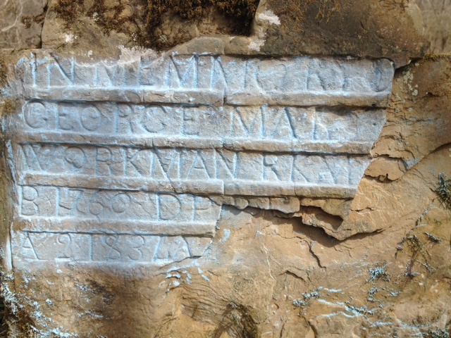
-George Workman, born 1760, died 183?
-Elizabeth Hawkins, born 1739, died 180?
-Chrsitian Wayra?, died 6 Jan ?. This grave is pictured in John Richards' book and the inscription says "Christian Wayra?, died 6 Jan 1802 A 100", but it has since faded away mostly.
Below are more pictures I took of the Old Republican Meeting House Cemetery:
 |
| Unknown inscription |
 |
| Remains of a possible burial crypt or cellar |
 |
| A damaged burial crypt |
 |
| Another view of the crypt/cellar that is partially buried |
 |
| A walled gravesite |
 |
| Resting place of John Hawkins |
 |
| Moss overtakes what man has carved |
 |
| An unknown soul |
 |
| Another illegible inscription |
 |
| A quite large burial crypt |
 |
| Walls bordering some graves |
 |
| George Workman, born in 1760 |
 |
| Elizabeth Hawkins' grave states she was born in 1739 |
 |
| A lonely, unknown grave marked by only a single rock |
|
Maybe someone who reads this will know more about this old cemetery and the people resting there. Maybe, too, someone will be able to close a genealogical gap in their family's story as a result of my Sunday expedition. And maybe, just maybe, these souls and the history of this once important area will live on in some way.
***A Follow up, January 29, 2015: Fellow history buff and news editor Cecil Lawson recently drove out to the cemetery site and sent a picture of the old stone house I saw. I also found a drawing of what the Old Stone Fort looked like that was in a publication the Bath County Chamber of Commerce released in 1961 for the 150th anniversary of Bath County. Based on the location and the pictures, we are confident that the old stone house in the woods is in fact the Old Stone Fort. It looks as if it was indeed a large house built similar to Morgan's Station near Mount Sterling. The house has fallen in from what we can tell, and we are working on getting permission from the property owner to inspect and photograph this historical site before the environment reclaims what's left of the house.
 |
| Illustration depicting the Old Stone Fort, courtesy of the Bath County Chamber of Commerce, 1961 |
 |
The Old Stone Fort, 2015, courtesy of Cecil Lawson
|
***A Follow up, July, 2015***
After reading this blog, local historians Richard Oldfield, Don Johnson and Ken Darnell explored the Old Republican Meeting House Cemetery and were able to clean some head stones and recover some of the names previously unseen. Here are some pictures they took that day:
On Memorial Day weekend, 2015, I took my sons to the site of the Old Stone Fort and took a close up picture of the ruins: